swisstopo - Explore Swiss maps & travel
Discover the beauty of Switzerland with offline maps, hiking trails & customizable tours at your fingertips!
- 1.15.0 Version
- 2.7 Score
- 575K+ Downloads
- Free License
- 3+ Content Rating


Traveling with the top-rated app of the year: the swisstopo application received the prestigious "Master of Swiss Apps 2021" award.
Utilize the renowned national maps to explore even the most secluded areas of Switzerland, covering activities such as hiking, cycling, winter sports, and aviation. All features and data within the app, along with offline capabilities, are offered at no cost. The app is free from advertisements and does not require user registration.
- various scales ranging from 1:10,000 to 1:1 million
- up-to-date aerial imagery and historical map collections
- designated official trails for hiking, mountain trekking, and alpine adventuring
- information on trail closures
- routes for snowshoeing and skiing
- pathways from SwitzerlandMobility
- locations of public transportation stops
ALIGNMENT WITH NATURE
- complimentary offline maps (scales from 1:25,000 to 1:1 million)
- create, document, import, and share your personal journeys
- specify type of activity (hiking, cycling, mountain biking) along with your preferred speed
- navigation assistant (estimated arrival time, remaining distance)
- panoramic viewing mode (labelled panorama views, ability to view tours in "3D")
- save locations, add comments, and share experiences
FUNCTIONALITIES like measuring, comparing, and searching (for geographical names, addresses, or coordinates)
Submit updates regarding maps and geographical data
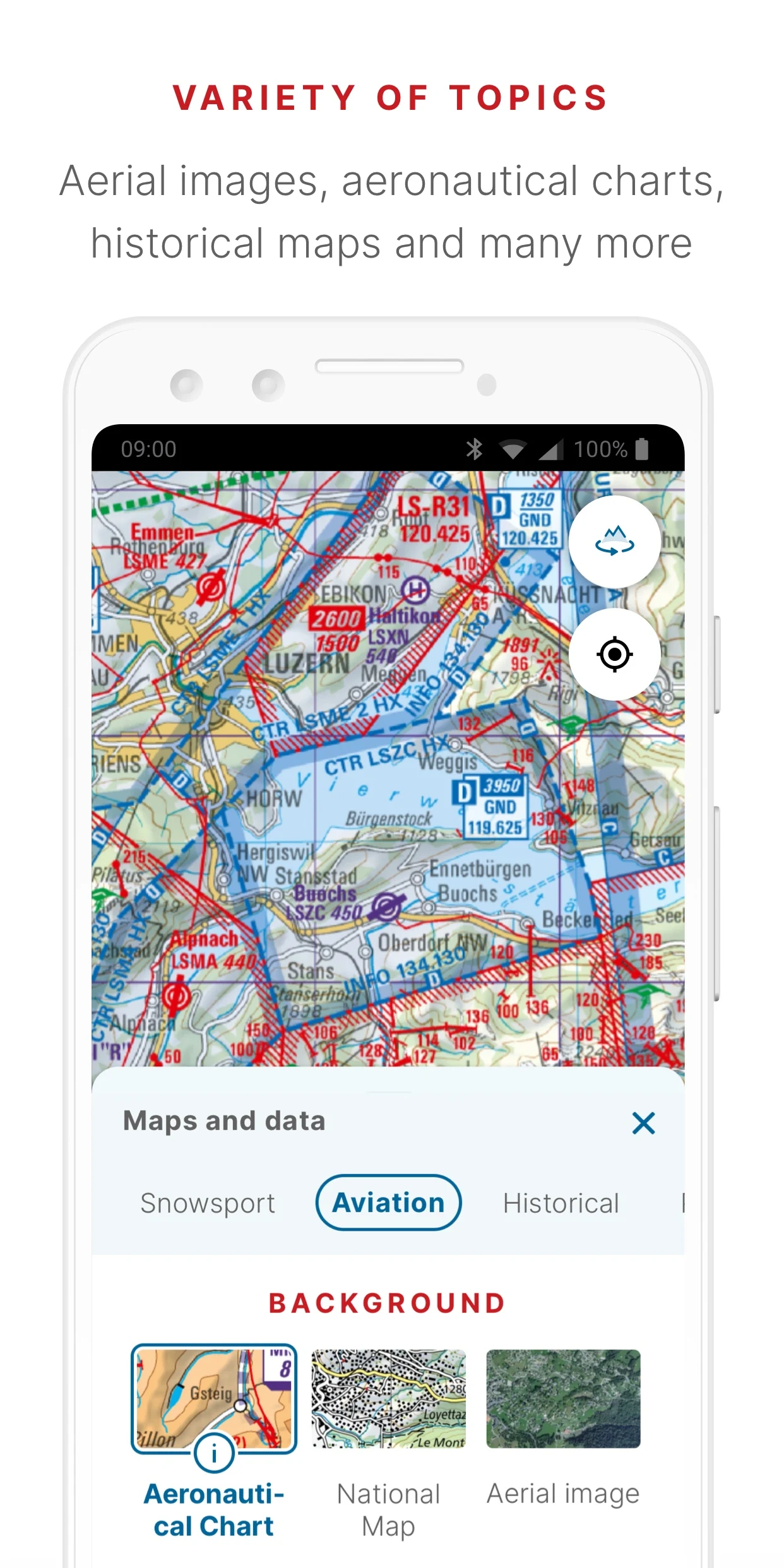
AIR TRAFFIC
- aeronautical charts, identified obstacles, airspace designations
- designated landing zones
- guidelines for drone and model aircraft usage
General information about the swisstopo app
Discover even the remotest places in Switzerland with high quality maps. The free map app from swisstopo lets you combine the National Maps of Switzerland with many other topics such as hiking, cycling, snow sports and aviation on your smartphone and tablet. Ease of use and functionalities for planning and recording tours as well as experiencing the landscape in panorama mode, are some of the highlights of the app.

swisstopo app: maps and geodata on your smartphone
Precise and versatile
The swisstopo app shows all National Maps from the scale of 1:10'000 to 1:1million, as well as aerial photographs, aeronautical maps and historical maps covering the whole of Switzerland. The maps are supplemented by additional information relating to public transport, hiking, cycling, snow sports and aviation. In addition to the official routes of the Swiss hiking trails, the app also contains SwitzerlandMobility routes. Depending on your interests, themes and content can be added to the background map.
Easy to handle and clear
The app's key features include simple usability, easy orientation and the ability to plan, guide and record tours. With the swisstopo app, your own position is displayed directly on the maps or aerial photographs. The coordinates and elevation data of the current location are always known. By searching for places, addresses, or coordinates, any destination can be found quickly.
Discover the panorama mode
You want to know which panorama surrounds you? With one click you look through your camera and the most important places and summits are labelled in the camera image. Or discover the view virtually from any point on the map.
Offline maps
Maps and data can be stored free of charge and without restriction and be used offline. This means that the maps can be used even if mobile network coverage is poor or non-existent.

27 April 2022
An app as smart as swisstopo
It’s never been so easy to plan a walk or bike ride. The swisstopo app acts as your expert guide, surprising you in the process with its wide range of features. The ingenious product has scooped the Master of Swiss Apps award.
More about «An app as smart as swisstopo»

8 January 2024
Quality and excellence
swisstopo places a great deal of value on quality and client satisfaction in the areas of data, products and services. In recent years it has received numerous awards and certifications.
More about «Quality and excellence»
- Version1.15.0
- UpdateMay 30, 2025
- DeveloperFederal Office of Topography swisstopo
- CategoryMaps & Navigation
- Requires AndroidAndroid 8.0+
- Downloads575K+
- Package Namech.admin.swisstopo
- Signaturebc9a7a315bd3104add04eb5a199d9d23
- Available on
- ReportFlag as inappropriate
-
NameSizeDownload
-
98.52 MB
-
90.88 MB
-
90.88 MB


User-friendly interface
Excellent base maps and overlays
Fast loading times
Good offline functionality
Accurate time estimates for routes
Easy route planning and editing
Customizable elevation profiles
High-quality topographical maps
Free to use
Frequent app crashes
Offline map issues
Missing essential features from old app
Difficulties with GPS tracking
Complicated navigation and menus
High cost of offline map subscriptions
Unreliable map loading under certain conditions
Limited capabilities for non-hiking activities
Requires Google location services