スーパー地形 - Terrain mapping & navigation
Discover the great outdoors with powerful terrain maps, GPS tracking, and engaging hiking features for adventure enthusiasts!
- 4.6.4 Version
- 2.0 Score
- 184K+ Downloads
- In-app purchases License
- 3+ Content Rating

Introduction
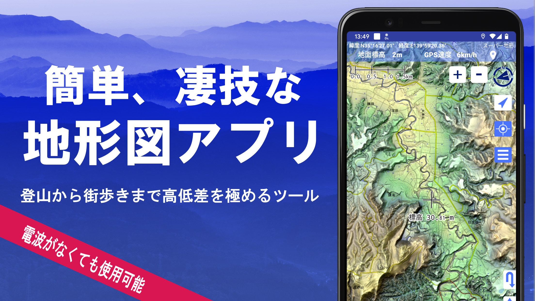
スーパー地形 focuses on terrain—letting hikers and map lovers explore landforms in detail, record routes, and study views before and after a trip. Choose from an expansive catalog of Japanese base maps, historical sheets, geology and relief visualizations, or bring your own layers from Kashmir3D. Download areas to use in signal-dead zones, log tracks with photos, and review them later in 3D. Panorama and line-of-sight tools help identify peaks and understand what’s visible from a ridge or valley. With recent higher-detail mesh coverage, the app doubles as a lightweight field notebook and a portable terrain lab.
Awarded the 2018 Japan Cartographic Society Award for Best Work.
Highlights
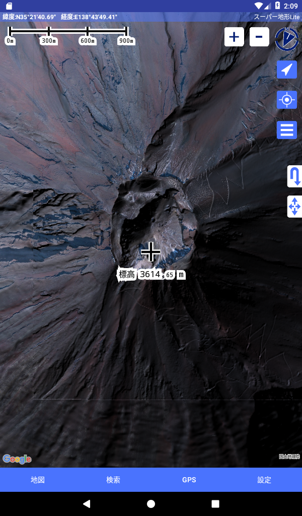
- Utilize "super terrain data" that highlights landscapes through innovative technology.
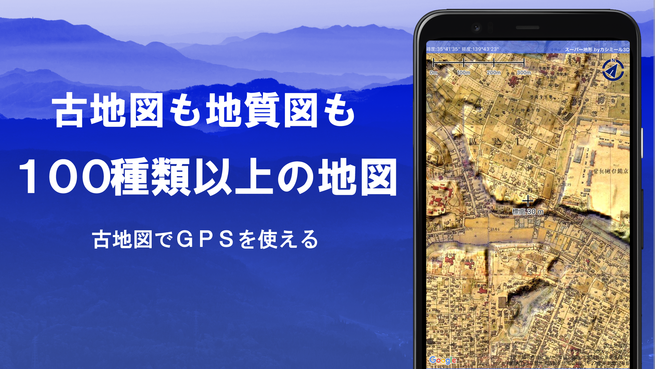
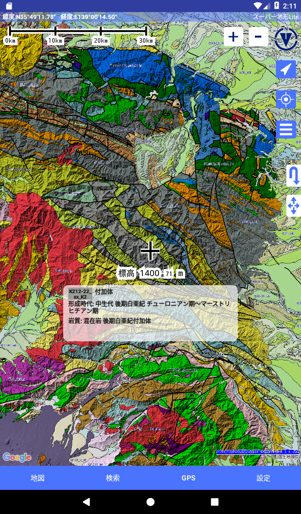
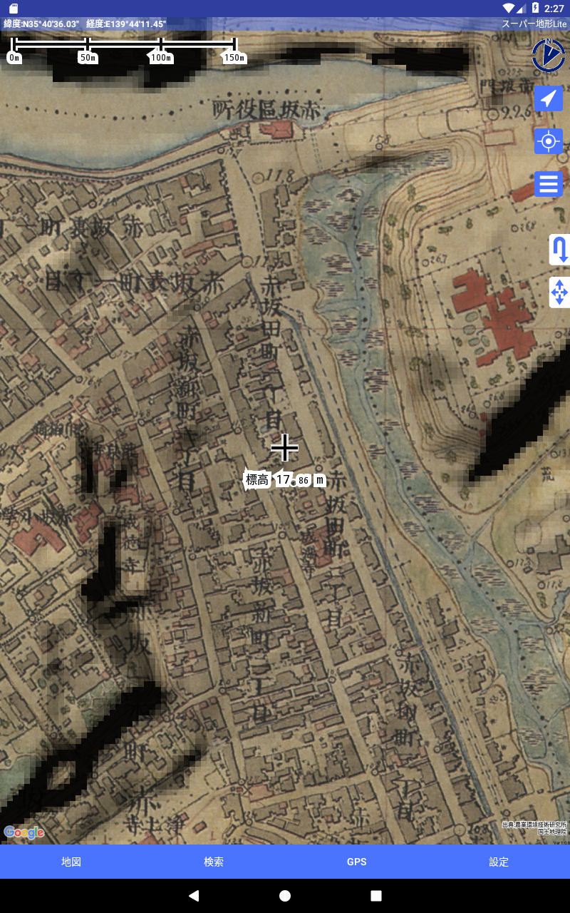
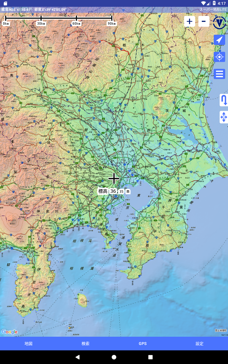
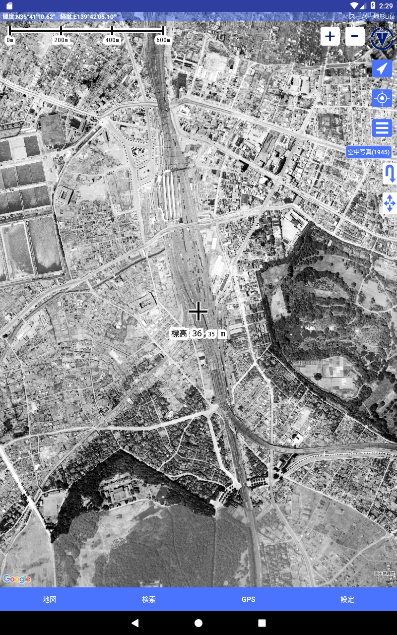
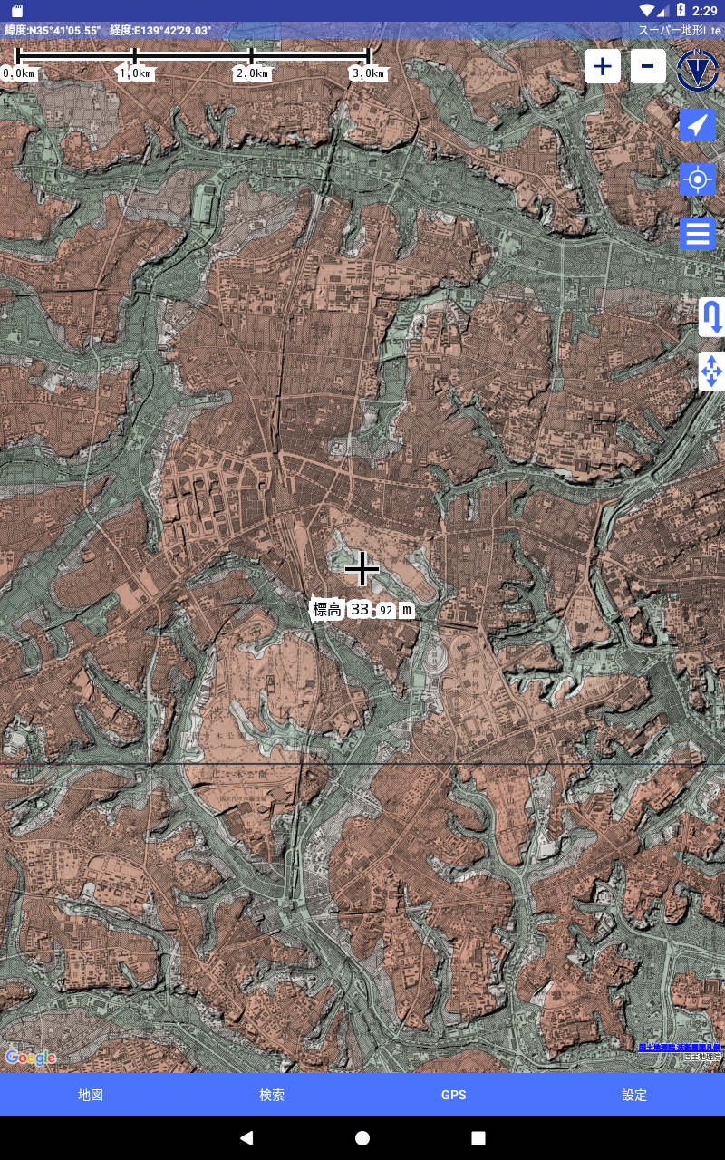
- Access maps from the Geospatial Information Authority of Japan’s Geographical Survey Institute including topographic maps, geological maps, former maps, and both historical and current maps.
- Record tracks (trajectories) via the GPS feature, which also supports GPX log input/output and editing capabilities.
- Equipped with features designed to assist with urban exploration, hiking, and outdoor activities, such as GPS navigation (with audio) and options for data recording and management.
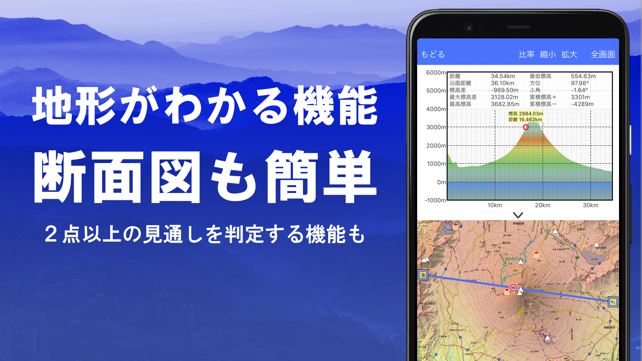
- Includes a visibility assessment function useful for creating cross-sectional diagrams or conducting observations. It can also present buildings on the map.
- Comes with a 360° panoramic view function that helps identify mountains by name and allows visibility of the sun, moon, and GPS locations.
- Supports GPS functionality, bulk map downloads, and caching, making offline usage possible when there is no network signal during climbing or outdoor adventures.
- You can attach photos to specific points on the map.
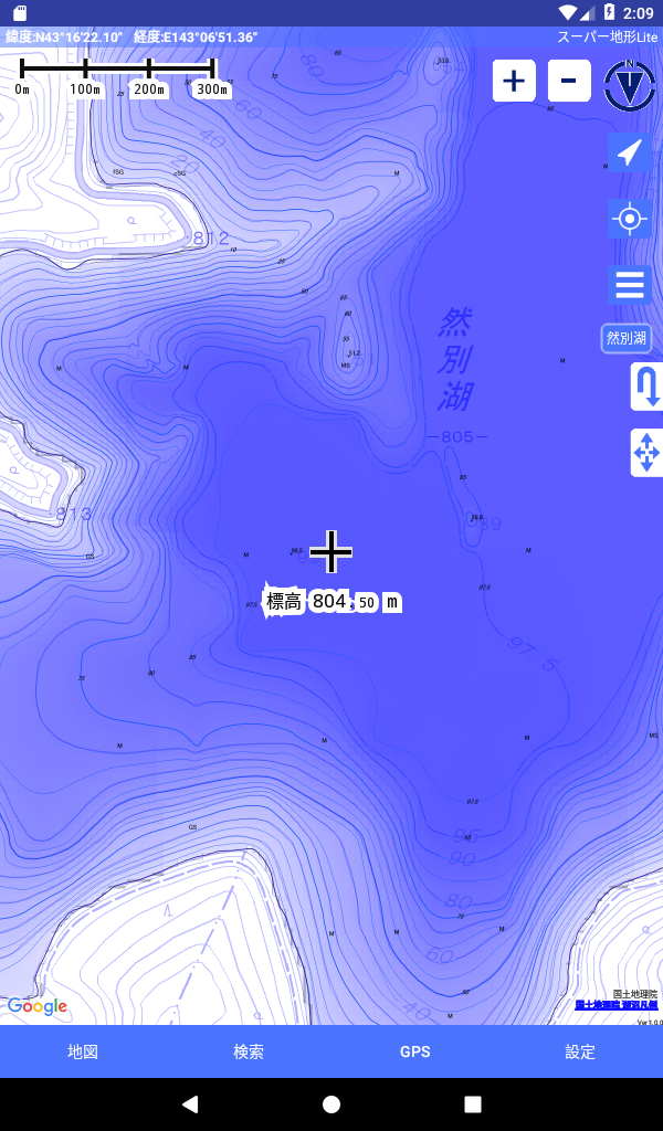
- Contour lines derived from elevation data are displayable.
- The MGRS grid (UTM grid) is included for reference.
- Ability to read, display, and modify GIS information from GeoJSON files.
- Facilitates shape drawing on the map.
- Usable internationally.
- Map printing and PDF creation are supported.
- Offers a dark theme option.
Functions
1.Extensive Map Availability
- Utilize various maps (over 100 types including combinations).
- This includes proprietary super topographic data, maps from the Geospatial Information Authority of Japan, hazard maps, and more.
*Availability of aerial photographs varies by age group, with some groups lacking images. Both "latest" and "around 1974" have relatively comprehensive coverage.
*Maps using super terrain data are accessible free of charge for five days post-installation.
2.Cross-Section and Outlook Creation
- Easily draw cross sections through any point on the map.
- Equipped with a familiar visibility judgment feature in Kashmir 3D, calculations account for the earth's curvature and atmospheric variations.
- This is beneficial for route checking while climbing and determining radio visibility, as well as understanding terrain features.
- Where PLATEAU building data exists, you can create a cross-section that includes structures.
3.Elevation Palette Feature
- The elevation palette function allows you to modify the background color of the map, adjusting it to your preferred gradient in 1cm increments.
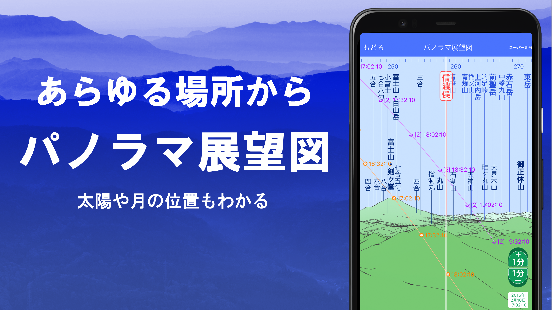
4.Panoramic View
- Create a panoramic observation map to identify mountain names from anywhere on the map. A 360-degree panorama that links to your smartphone’s compass enhances mountain identification.
- You can visualize the sun and moon (including lunar phases). This assists in exploring prominent features like Diamond Fuji and Pearl Fuji.
- The location of GPS points is also viewable.
- Panoramic views of international mountains can be created as well.
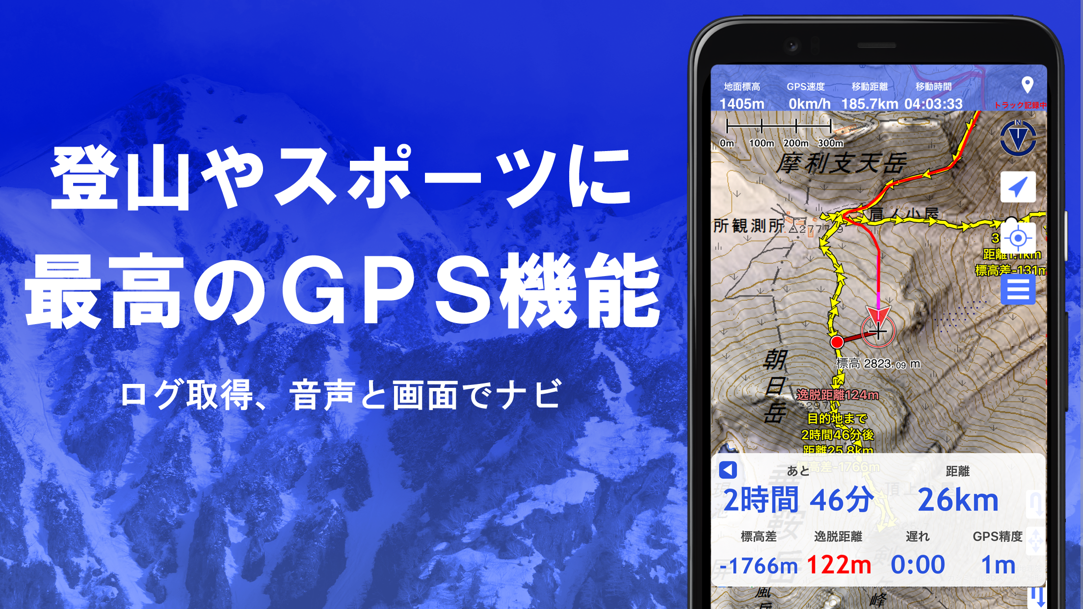
5.GPS Functionality
- Acquire location details through your smartphone’s GPS and record tracks effectively.
- Utilizes high-precision positioning suitable for serious hiking and outdoor activities.
- Graphical display of recorded tracks includes parameters such as elevation change, speed, time, and elapsed duration.
- An alert system will notify you with sound cues when approaching specified points.
- You may link photos to these points for visual reference.
- You can share the central position of the map with NaviCon.
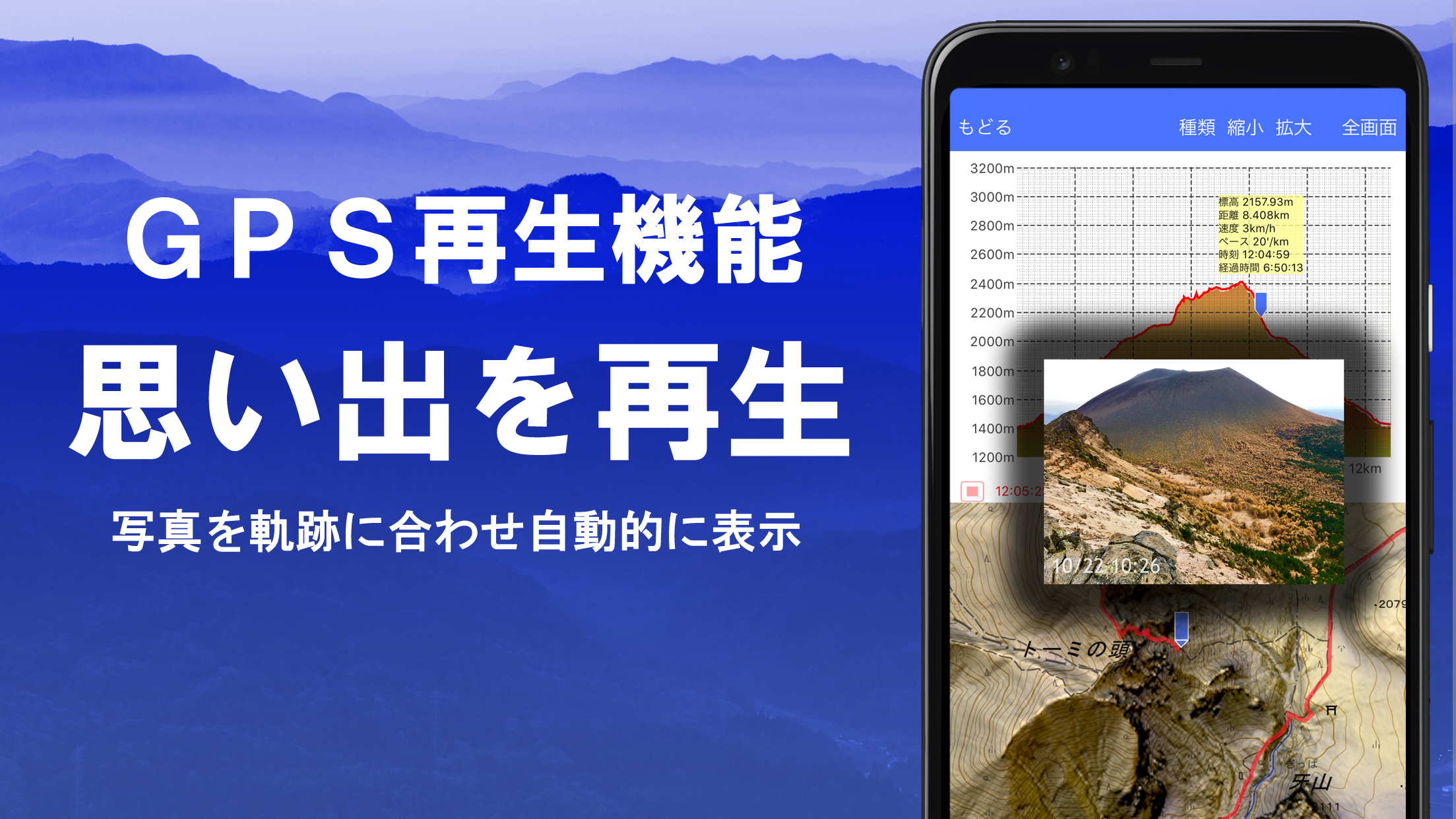
6.GPS Track Summary Playback
- This feature enables complete playback of track records.
- It compares timestamps of photos saved on your smartphone and automatically shows corresponding pictures.
- Tapping on the displayed icon at photo locations reveals the images.
7.GPS Navigation Function
- Includes a function (Track Navi) for navigating along established paths using your smartphone’s GPS.
- If you stray from the set path, a voice or alarm alerts you.
- This ensures you stay oriented while climbing.
- Additionally, route navigation utilizing route data is available for urban exploration, as well as point-to-point navigation aimed at specific locations.
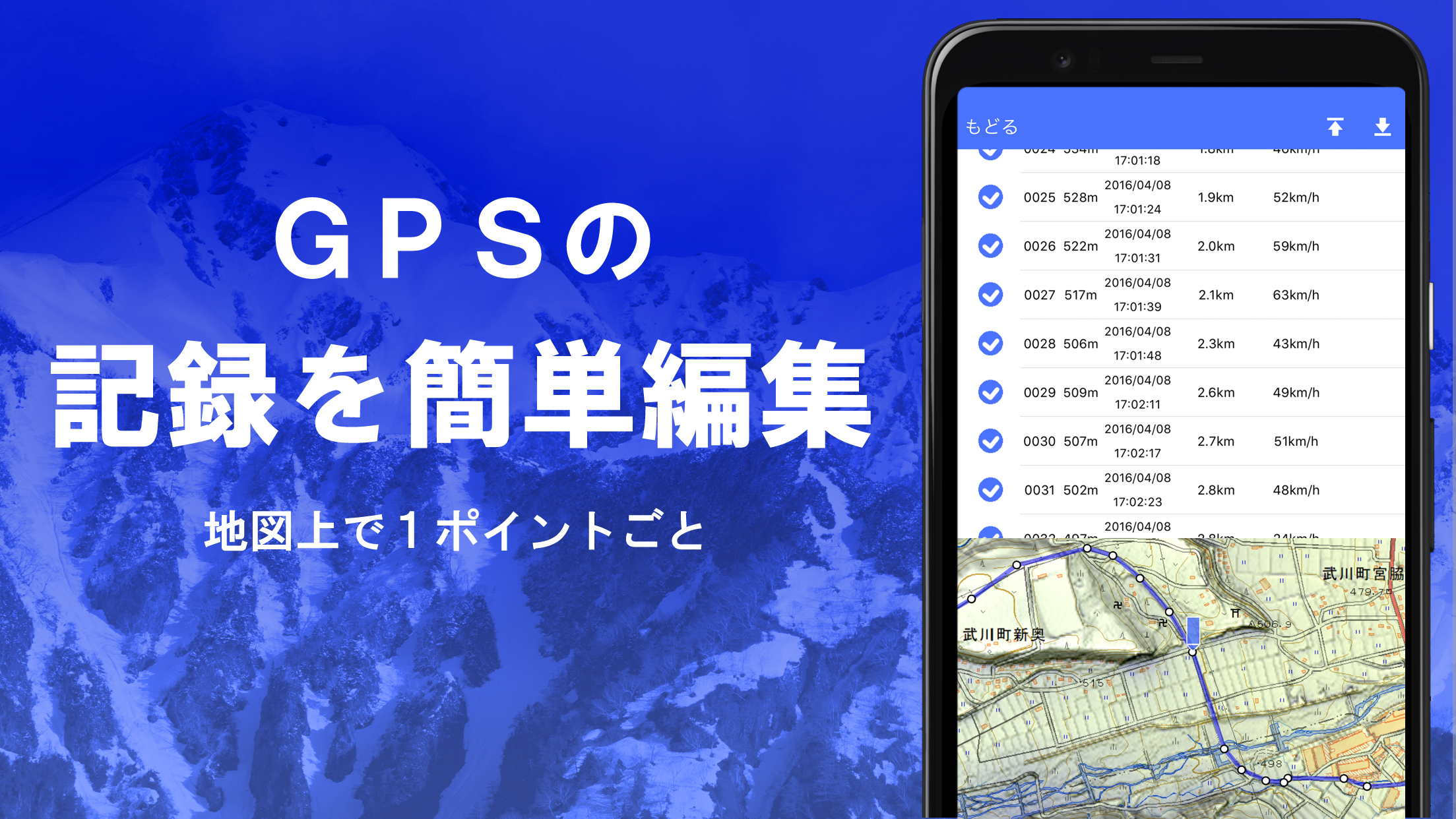
8.GPS Data Editing Capabilities
- This allows management of GPS point, route, and track data.
- Data can be organized in folders, presented in a reader-friendly tree structure.
- You can also create tracks directly on the map.
- Importing and exporting GPX format data from hiking sites is another possibility.
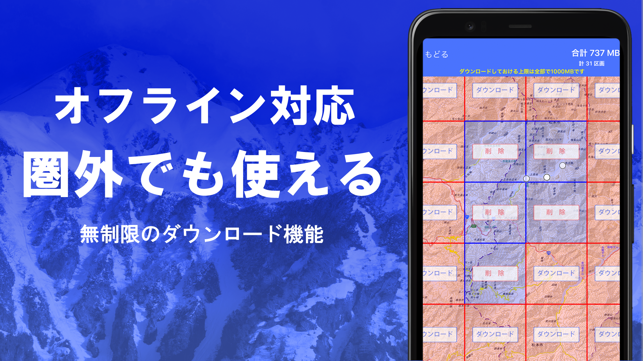
9.Offline Map Use
- Access maps even when climbing mountains or visiting areas without signaI.
- The bulk download feature allows you to acquire all scale maps for selected regions.
- Monitor your downloads at a glance, preventing scenarios where maps are unavailable on-site.
- A caching function is also included.
10.Map History Feature
Remembers previously viewed locations, enabling easy return to earlier spots.
11.Custom Map Compatibility
- Import and utilize custom maps created with Kashmir 3D’s map cutter.
- Your individual maps and scanned documents can be displayed and utilized effectively.
- When using the map cutter, ensure each image is divided into approximately 256 x 256 segments.
- Submit the generated kmz file to Super Terrain via email or cloud storage.
12.GeoJSON Support
- Display and edit points, linestrings, and polygons from GeoJSON formatted files.
- Drawing new shapes is achievable as well.
13.Printing/PDF Output
Allows any designated map area to be printed at a specified scale or converted into a PDF format.
14.Integration with Other Apps
- GPS data can be input and output in GPX, KML, and GDB formats.
- Enables data exchange with other applications, including the PC version of "Kashmir 3D," and leverages trajectory data from hiking websites.
15.Backup Capability
- All app data (excluding cache maps) can be backed up and removed from the smartphone.
- This enables data retrieval even if the app is deleted or the smartphone faces issues.
- An automatic backup option using Google Drive is also available for consistent updates.
- Refer to the manual for further details.
16.Billing Information
Certain functions, including maps utilizing super terrain data, GPS tracking, and cross-sectional views, require in-app purchases. Also, after purchasing, the number of results for place name searches increases.
●Fees
Annual payment: 780 yen/year
●Free Trial
*Enjoy a complimentary trial of the app for five days post-initial installation.
*After the five-day period, access to some features and maps will be restricted.
*No charges will occur unless a purchase is made.
*To proceed with a purchase, navigate to [Settings] - [Purchase to remove functional restrictions] within the app.
●Confirmation and Cancellation
Check the timeline for automatic updates or cancel them through the following steps:
1) Open Google Play
2) Select "Regular Purchase" from the menu
3) Find "Super Terrain"
●Price Changes
*Pricing may vary due to future enhancements in functionality.
*Purchasing early could be advantageous.
17.User Agreement
- The copyright owner and developer hold no accountability for outcomes from operating this application.
- Upon initiating GPS for the first time, a prompt will ask if you allow the use of location services. Please grant permission.
- Frequent use of the GPS feature may drain battery life.
- If the device serves emergency communication purposes, consider carrying a spare battery as a precaution.
- A clear explanation of the navigation function is available in PDF format.
- Recording tracks may be interrupted or not work correctly on some smartphones due to power-saving features closing the background app, a limitation that affects various apps.
- While using super terrain, track recording may persist briefly if the screen dims, but there's no fundamental fix to this behavior. Please take note of this.
Rewrite elevation values in track logs: Super Terrain App
-- Have you ever found that the "Super Terrain" app that can be used for city walks, mountain walks, map exploration, etc., has a lot of disturbances in the graphs in the track log? In some places, GPS elevation readings may deviate from the actual situation.
-- It is possible to attach it to the ground later.
-- Be careful when it includes airplane records. It lands.
(Map app to feel the terrain - Super TerrainFrom walking around the city to climbing mountains, an easy and amazing topographic map appwww.kashmir3d.com)
-- The elevation value in the track log record records the smartphone measurement.
-- Accuracy varies depending on the model, and it may deviate greatly from the ground and become disturbed.
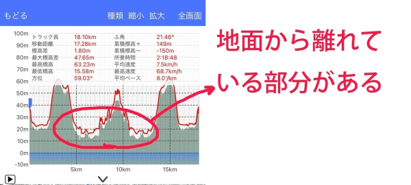
- Disturbance in track recording graphs
-- In such a case, it is possible to attach only the elevation value to the ground later.
-- From the track list, tap the track and choose Convert from the menu.
-- If you rewrite it, the original elevation value will disappear, so if you want to keep the original data, please copy it in advance.
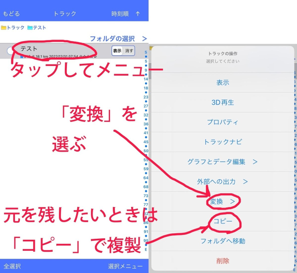
- Choose the "Convert" menu
-- Next, select "Rewrite with elevation data".
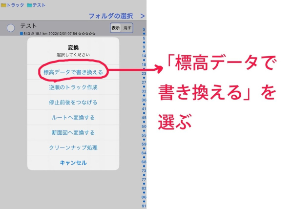
- Select "Rewrite with elevation data"
-- If you say "yes" in confirmation, the rewriting is complete. If you look at the graph, you can see that it is perfectly on the ground.
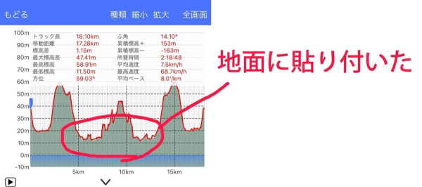
- Rewrite complete
Add Info
[Super Terrain Data]
- Based on the 5m basic map information covering the whole of Japan, high-density super terrain data can be used.
- There are no holes like the base map information.
- Please note that "Super Terrain Data" is in the form of an online map. The necessary parts are downloaded sequentially when needed.
- It can also be used as a normal map.
*Where the 5m mesh is not maintained, we interpolate with a 10m mesh. There may be a step in the elevation of the interpolated part.
[3D function available]
In the "Free Basic Set", all functions of Kashmir 3D, such as 3D display, cross-sectional view, and elevation value, are available, which could not be used without obtaining elevation data separately.
[Dedicated topographic expression that emphasizes unevenness]
- The newly developed Super Terrain Data, which can only be used (as of 2015), can be used with the [Relief]-[Super] setting.
- From microtopography to mountains, new discoveries can be made with unprecedented topographic representations.
- It is a terrain representation that can only be used in Kashmir 3D.
[Dedicated elevation pallet]
- From lowlands to high elevations, dedicated elevation palette settings are available for excellent terrain representation.
- You can also change the palette to a non-dedicated one.
- You can also edit the palette to make it color-coded to your liking.
[GSI Map and Aerial Photo]
- You can use a combination of GSI maps and aerial photos (GSI maps) for super terrain data.
- You can overlay maps and aerial photos on top of the terrain representations in the Super Terrain Set.
- It can also be used as background elevation data for the tilemap plugin.
[Drawing shapes]
- It comes with a geopad plug-in (release version) that allows you to draw various shapes on the map.
- It can also be displayed in the Cassible image after shooting.
[Tile Map Plugin]
- Super Terrain Data is a tilemap plugin that can be used as background elevation data.
- You can use the Tile Map plugin to overlay a variety of maps.
- "Seamless Geological Map" + "GSI Map" + "Super Terrain Set"
[Sample Image]
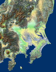
Kanto Super Topographic Map
Enlarge
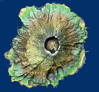
Miyakejima
Expansion
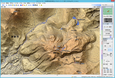
Map of
Kita-Yatsugatake Enlarge
[license]
license
- To use the Kashmir 3D Super Terrain Set, you need a license.
- The license includes one year's worth of usage and costs ¥1,680 (tax included).
*If you have a Mountain Travel Club license, you can use it free of charge, so you do not need to purchase a license.
*If you are using Mountain Travel Club, please download and override the Super Terrain Set.
*You cannot upgrade from a Super Terrain Set license to a Mountain Travel Club license.
You can try it out
Download and install [Kashmir 3D Super Terrain Set] and try it out for 3 days without any functional limitations. Please purchase a
license before trying it out thoroughly.
- Version4.6.4
- UpdateSep 28, 2025
- Developerkashmir3d
- CategoryMaps & Navigation
- Requires AndroidAndroid 5.0+
- Downloads184K+
- Package Namecom.kashmir3d.superdem
- Signature862b83a4be4a8912a23770f47a856849
- Available on
- ReportFlag as inappropriate
-
NameSizeDownload
-
17.62 MB
-
13.49 MB
-
13.14 MB