BRouter Offline Navigation - Offline biking routes & navigation
Discover the ultimate offline bike routing app that generates customizable paths while considering elevation for optimal journeys.

- 1.7.8 Version
- 1.1 Score
- 200K+ Downloads
- Free License
- 3+ Content Rating

APP at glance
BRouter Offline Navigation is a routing engine that calculates paths on your phone without an internet connection, then hands results to your favorite map app. After downloading regional data, you can plan trips that respect hills, surfaces, and your chosen travel style—road cycling, touring, MTB, hiking, or even energy-based driving. Routes can include waypoints, alternatives, and “avoid” zones, and enthusiasts can adjust profile files to shape behavior further.
-- A customizable, elevation-sensitive (bike) router designed for offline navigation utilizing open data. It operates alongside a mapping application.
-- Documentation can be found on the official BRouter site.
-- There is also an online version available for users who prefer web access.
Here's what makes BRouter unique:
- It uses freely configurable routing profiles
- It works fully offline on any Android phone and is interfaced to some of the most popular Android map tools
- It uses a sophisticated routing-algorithm with elevation consideration
- It offers alternative route calculations
- It supports via and nogo-points
- It can consider long distance cycle routes
- Routing data is available worldwide with automatic weekly updates
- BRouter uses OpenStreetMap
- BRouter uses user-generated, collaboratively collected free geodata. Thanks to OpenStreetMap.org and contributors - please donate your geographic data to openstreetmap.org! See the License description for details.
Online versions
- Check brouter-web if you want to use BRouter online. Or use the simple old online version as a fallback in case your browser cannot run brouter-web
- Android app for offline routing
- See offline routing app for how to setup BRouter for offline routing on an Android smartphone.
Notice
*** If you are unfamiliar with any of the compatible map applications, the BRouter-App will not be helpful to you. Please only download if you are ready to invest time in understanding how to set it up. Kindly refrain from giving one-star reviews due to impatience! Assistance is not provided via email for problems. ***
== BRouter focuses solely on route calculation and does not feature a map display or visual representation of the route independently; hence, it must be used alongside a mapping application. There are two primary interfacing methods between BRouter and the map application: BRouter supplies a service interface that the map application can call without launching the BRouter-App, making it function similarly to an online routing service, which includes real-time recalculations if you deviate from the planned route. Alternatively, users can start the BRouter-App directly and utilize waypoints from the map application's database to outline their journey. The resulting route is saved as a GPX file (including the elevation profile) in the map application's track directory.
== Several well-known map applications currently support both the service interface and waypoint database interaction in their versions available on Google Play.
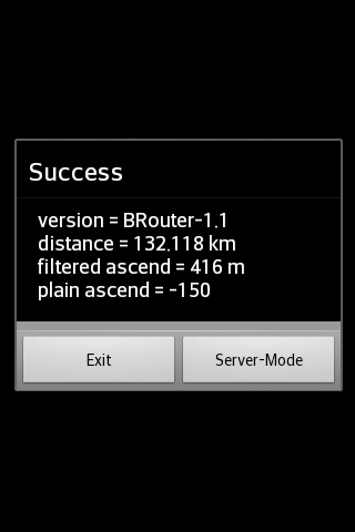
== The service interface has a timeout limit of 60 seconds, restricting its use to distances of approximately 50 km; however, using the BRouter App allows for calculations over much longer distances. Long-distance routes can still be tracked through the service interface by initially calculating a route for your endpoint with the BRouter App and assigning it to a routing mode using the "Server-Mode" button. This aspect is referred to as "timeout-free recalculations".
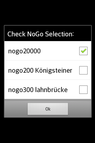
== Route calculations, whether conducted via the service interface or the BRouter App, take into account no-go areas that can be designated as waypoints using a specific naming convention (for example, "nogo200" for a 200m radius). This capability allows for the consideration of actual obstacles while also accommodating personal preferences.
== BRouter includes a download manager that facilitates the downloading of necessary routing data files. This download manager activates upon the first launch of the app and is made available later when internet connectivity exists.
Changes that have occurred
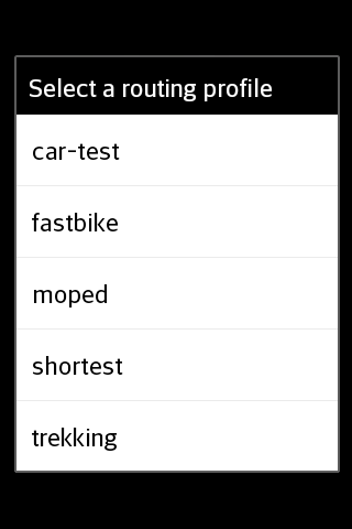
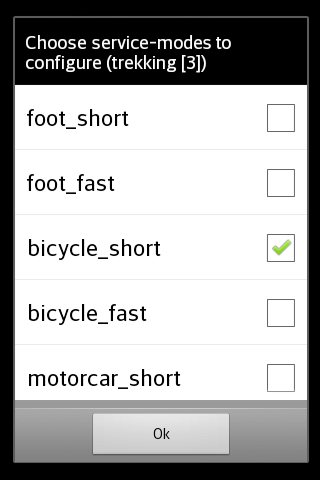
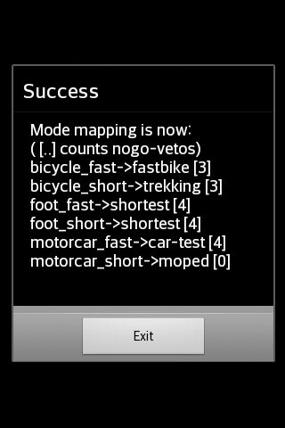
The mapping from one of the six traditional routing modes (car/bike/foot * fast/short) to BRouter's fully configurable routing profiles results in the following default mappings after installation:
car-fast -> car-test
car-short -> moped
bike-fast -> fastbike
bike-short -> trekking
foot-fast -> shortest
foot-short -> shortest
This mapping can be altered at any time using the "Server-Mode" button within the BRouter App. Additionally, routing profile definitions can be modified or new ones created.
Routing for cars is presently in an experimental phase ("car-test") and is not advisable for regular use, as turn restrictions are not accounted for.
Other bike routing resources:
- openstreetmap wiki router comparison matrix
- OpenRouteService.org
- Naviki.org
- yournavigation.org
- maps.cloudmade.com
- graphhopper.com
- cycle.travel
- Version1.7.8
- UpdateSep 29, 2025
- DeveloperDr. Arndt Brenschede
- CategoryMaps & Navigation
- Requires AndroidAndroid 5.0+
- Downloads200K+
- Package Namebtools.routingapp
- Signaturebeb4adee05f6d561c2c129c90d6f2c53
- Available on
- ReportFlag as inappropriate
-
NameSizeDownload
-
3.11 MB
-
3.08 MB
-
2.99 MB


Offline routing capabilities
Integration with Locus Maps and other navigation apps
Provides accurate alternative routes
Customizable routing options
Strong support for hiking and cycling routes
Free to use
Useful for long-distance planning
Works well without internet connection
User feedback leading to improvements
Poor user interface design
Steep learning curve for new users
Connectivity issues with certain devices
Requires another app for route display
Limited background download functionality
Confusing initial setup instructions
Inconsistent routing information in some areas
May crash unexpectedly during configuration
Lack of comprehensive documentation and manuals