Tracklia - Map & manage GPX files
Easily import, edit & export GPX, KML/KMZ. Record your adventures & share with friends using versatile mapping tools!
- 1.16.2 Version
- 1.5 Score
- 455K+ Downloads
- In-app purchases License
- 3+ Content Rating

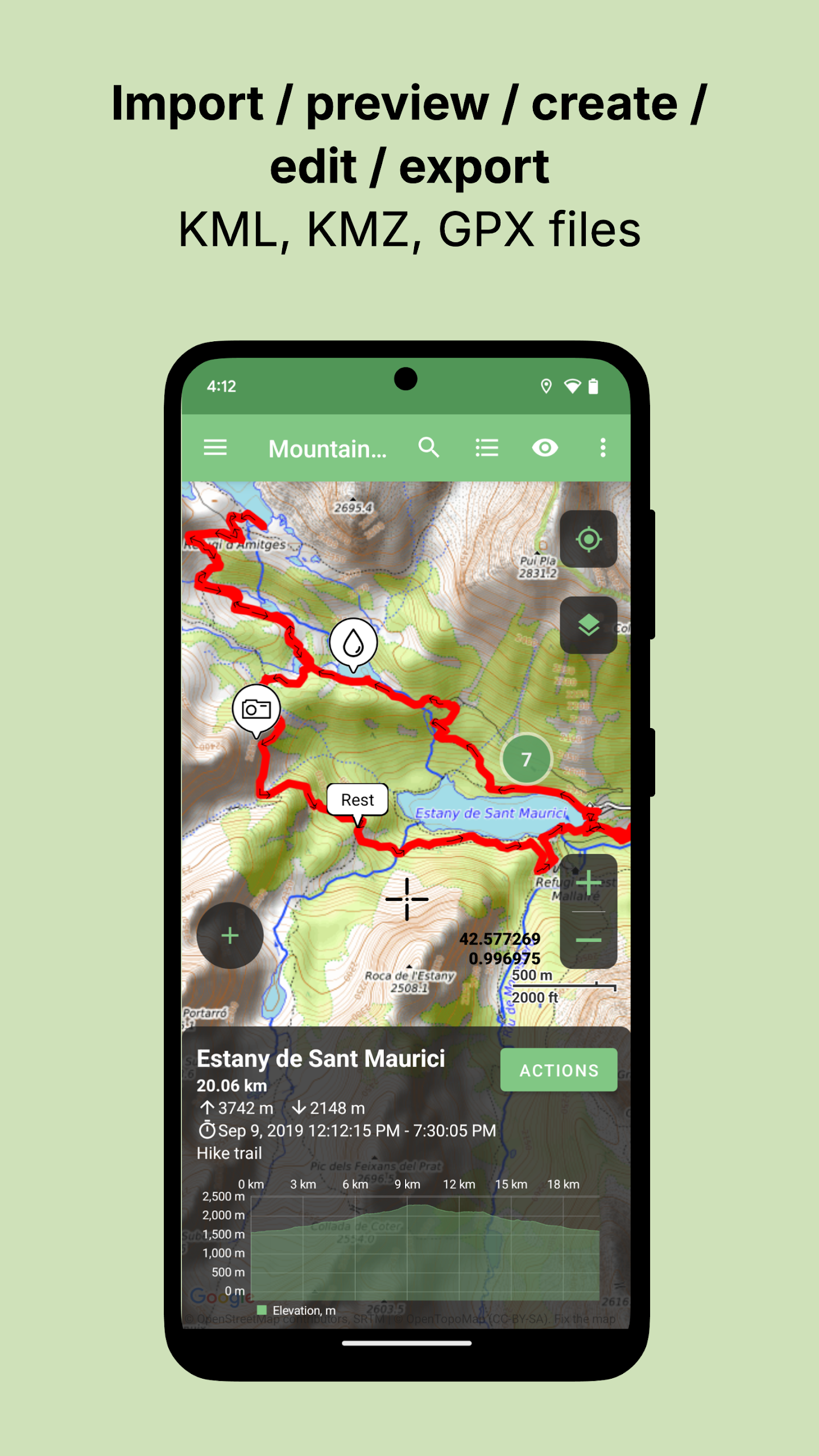

TRACKLIA is the pocket-sized powerhouse for anyone who works with GPX, KML, or KMZ files. Whether you’re plotting tomorrow’s mountain-bike epic, refining last week’s hike, or simply want a lightweight navigator that works offline, TRACKLIA puts every tool you need into one clean map-centric workspace. Import, record, edit, merge, split, annotate, and share your adventures—all without touching a desktop computer.
KEY FEATURES
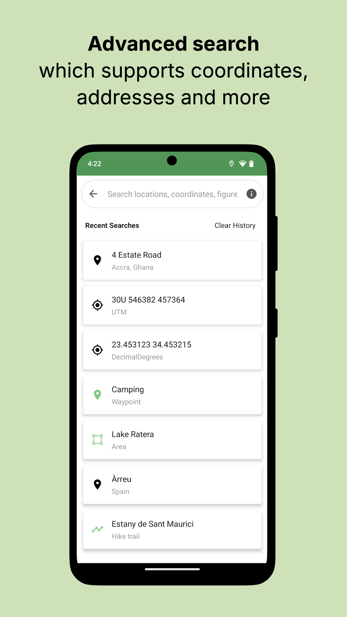
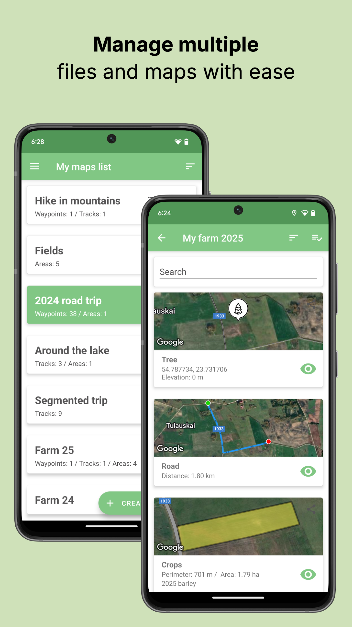
File Support & Import
• Open GPX, KML, and KMZ files in seconds.
• Cherry-pick only the tracks, routes, areas, or waypoints you need—no bulk clutter.
Recording & Statistics
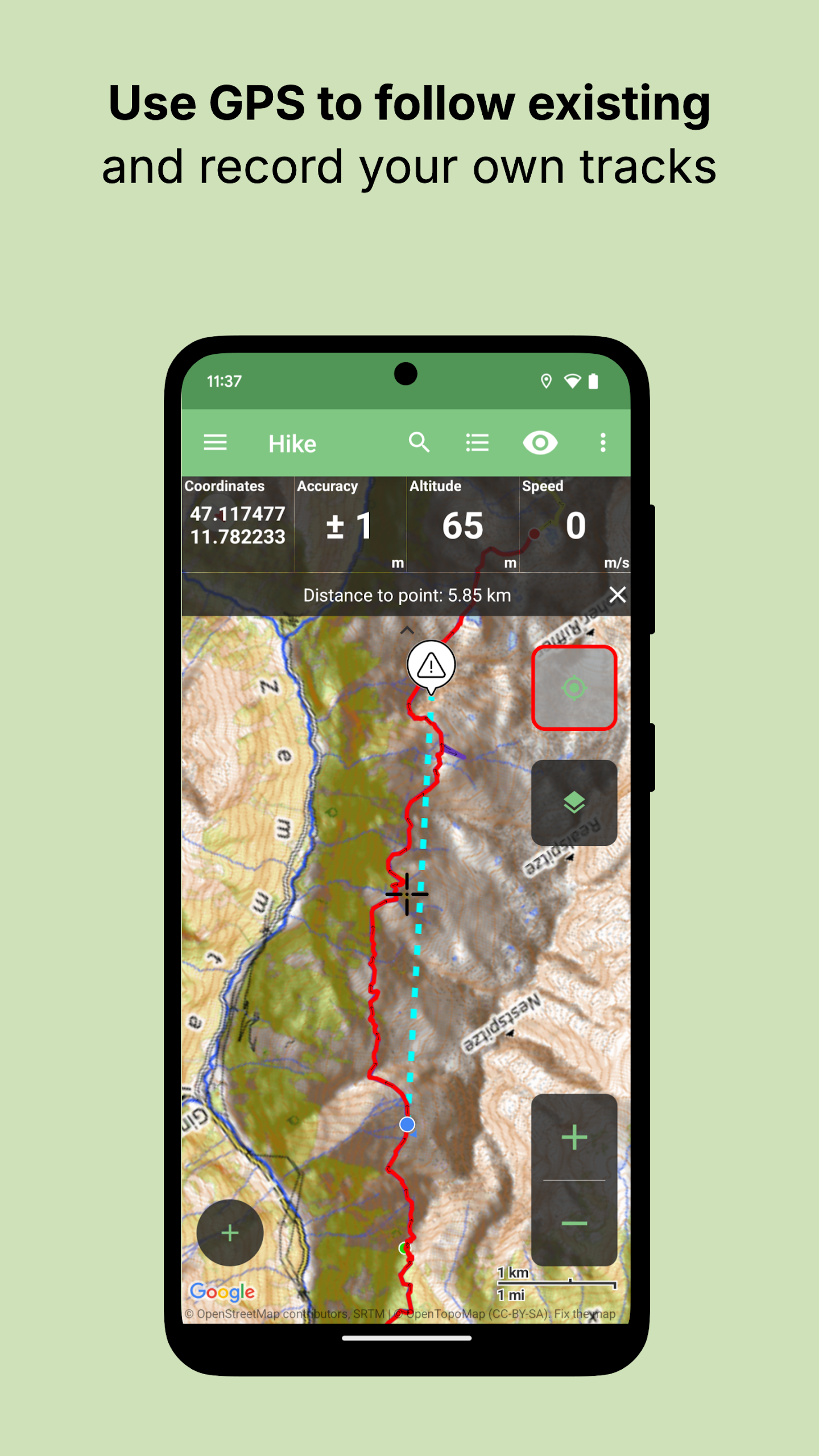
• Record a fresh GPS track in real time.
• Instantly view distance, elevation profile, total ascent/descent, and speed stats.
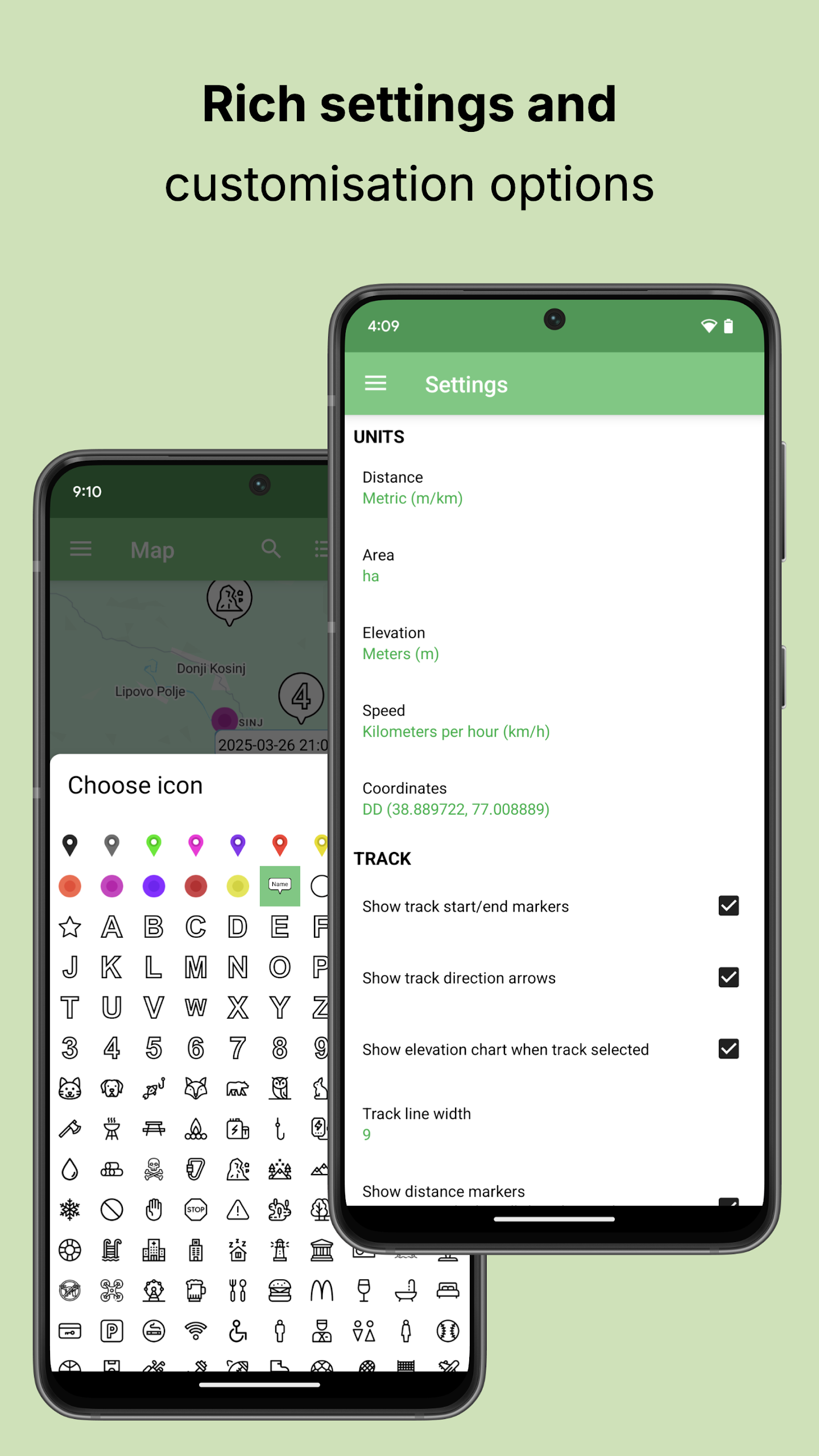
Editing Toolkit
• Add, move, insert, or delete individual points.
• Bulk-select and delete multiple points at once.
• Rename tracks, areas, or waypoints; update descriptions; swap waypoint icons.
• Reverse a track, split long tracks into segments, or merge several tracks into one (perfect for stitching Strava fragments).
• Attach geotagged photos to any waypoint, route, or area.
Creation & Export
• Draw new tracks or polygonal areas freehand or point-by-point—with live distance/area readouts.
• Drop waypoints anywhere on the map.
• Export finished data to GPX, KML, or CSV (for spreadsheets).
• Share directly to Google Maps, other navigation apps, or friends via email/messaging.
• Sketch on the map with your fingertip and send the snapshot as an image.
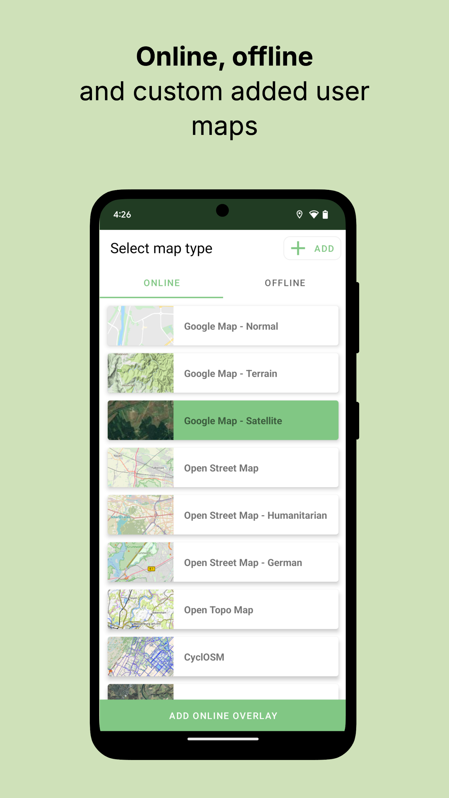
Map Choices
Offline: OpenStreetMap vector tiles stored on your device.
Online: Google Maps (Normal, Terrain, Satellite), OpenStreetMap, Humanitarian, OpenTopoMap, Hike&Bike, Wikimedia, Esri Aerial, plus any custom tile URL you provide.
Navigation Mode
• Real-time GPS dot with coordinate, altitude, speed, and accuracy readouts.
• Auto-follow and auto-rotate map to your bearing.
• Works with offline tiles when you’re beyond cell range.
Language Support
Deutsch, English, Español, Français, हिन्दी, Indonesia, Português, Українська, Türkçe, Tiếng Việt.
HOW TO USE
Import Existing Data
• Tap “Import”, choose your GPX/KML/KMZ source (cloud, email attachment, USB, etc.), then tick the items you want.
• Files appear in the “My Maps” list; tap any entry to view on the map.
Record a New Track
• Hit the red “Record” button, give the track a name, and start moving.
• Pause or stop anytime; stats and elevation are calculated automatically.
Edit or Combine
• Open a track → “Edit” to move points, insert new ones, or delete sections.
• Use “Merge” to select multiple tracks and join them end-to-end.
• Choose “Split” to cut a long hike into day-long segments.
Add Waypoints & Photos
• Long-press on the map to drop a waypoint, then tap it to rename or attach a photo.
Create From Scratch
• Tap “+” → “New Track/Area”, tap each desired vertex on the map, and finish to see live distance or area.
• Add standalone waypoints the same way.
Export & Share
• From “My Maps”, long-press any item → “Export” → choose GPX, KML, or CSV.
• Use the share sheet to send via email, WhatsApp, or open directly in another navigation app.
Navigate Offline
• Before leaving home, download the OpenStreetMap region (Settings → Offline Maps).
• Toggle the compass icon to enable auto-follow and map rotation while you hike, ride, or drive.
- Version1.16.2
- UpdateAug 18, 2025
- DeveloperTracklia Inc.
- CategoryTools
- Requires AndroidAndroid 5.0+
- Downloads455K+
- Package Nameapp.tracklia
- Signatureaf0b65770e8b1d449b4360be64b0c30b
- Available on
- ReportFlag as inappropriate
-
NameSizeDownload
-
16.99 MB
-
15.81 MB
-
14.96 MB


User-friendly free mapping solution
Excellent for basic uses
Good offline mapping features
Easy to import/export various file formats (GPX, KML)
Useful for tracking and maps editing
Supports a wide range of map types
Helpful for planning hikes and biking trails
Generally stable performance with pro features
Convenient for logging walks and trails
Not user-friendly interface
Difficulties in editing tracks
Limited offline functionality
Issues with exporting routes
Crashes with large files
GPS data inaccuracies with external antennas
Lack of certain measurement tools and compass functions
Subscription model seen as unappealing
Needs improvement on usability and customization options