AlpineQuest Explorer Lite - GPS maps & navigation
Navigate trails, maps, and GPS tracking for outdoor adventures.

- 2.3.9d Version
- 4.4 Score
- 2M+ Downloads
- Free License
- 3+ Content Rating


No advertisements ~~ No data sharing & monetization ~~ No analytics ~~ No third-party libraries
AlpineQuest is the complete solution for all outdoor activities and sports, including hiking, running, trailing, hunting, sailing, geocaching, and off-road navigation.
You can access and store a variety of online topographic maps locally, ensuring availability even without cell coverage. AlpineQuest also supports various on-board file-based raster map formats.
By utilizing your device's GPS and magnetic sensor for compass display, you can stay on track in real-time on the map, which can be oriented based on your view.
Save and retrieve unlimited placemarks, share them with friends, track your path, view advanced statistics and interactive graphics. With AlpineQuest, you'll have everything you need for outdoor exploration.
Being fully functional offline, AlpineQuest is ideal for wilderness adventures in remote areas or abroad.
Try out the Lite version for free now!
Common Questions:
1. Does this application also work on an iPhone (IOS)?
Unfortunately not, this application is only for Android devices.
The reason is simple, the Android version does already take all of our time.
2. I have just purchased the application on the Play Store, but the download doesn't start or fails
This is an issue in the Google Play application and unfortunately there is nothing we can do. You just need to wait some time and the download will start. Note that if you are installing multiple applications at the same time, they will not be installed altogether and some of them will be paused.
3. I want to re-install the complete version on my device but the Play Store ask me to pay again
Be sure that:
- You have purchased the application on the Play Store and not on our website using PayPal;
- You are using the same Google account you used when you purchased the application;
- You didn't cancel your order, asked for a refund or received an automated refund.
If you have any doubt, contact us by email with your Google Play purchase order ID so we can check its status.
4. Is is possible to transfer the application from one Google account to another?
Unfortunately not. Google doesn't allow it yet.
5. Is built-in data synchronizing planned for the future?
No, for many reasons:
- It can be done using dedicated apps, we don't want to reinvent the wheel;
- We'll never done it better that it's currently done by dedicated apps;
- Based on the large number of Cloud providers, only supporting the main ones will require a huge amount of time;
- We try to make the application as much offline as possible;
- We try not to rely on third party frameworks;
- We are developing a mapping application, not a syncing application.
Key features of the full version include:
★★ Maps ★★
• Online maps available with automatic local storage (including road, topo, and satellite maps) and online layers (road names, hillshade, contours);
• Access more online maps and layers from the community maps list with a single click (global and local topo maps);
• Complete area storage of online maps for offline usage;
• Support for on-board offline maps (raster) such as KMZ Overlays, OziExplorer OZFx2, OZFx3 (partial), calibrated images, GeoTiff, GeoPackage GeoPkg, MbTile, SqliteDB, and TMS zipped tiles (MOBAC, the free map creator);
• QuickChart Memory Map support (.qct, not compatible with .qc3);
• Built-in image calibration tool for using scans or pictures as maps;
• On-board storage of digital elevation models (1-arcsec SRTM DEM) and HGT elevation files (1-arcsec and 3-arcsec resolutions) for terrain, hillshade, and slopes display;
• Support for Polar maps (Arctic and Antarctic);
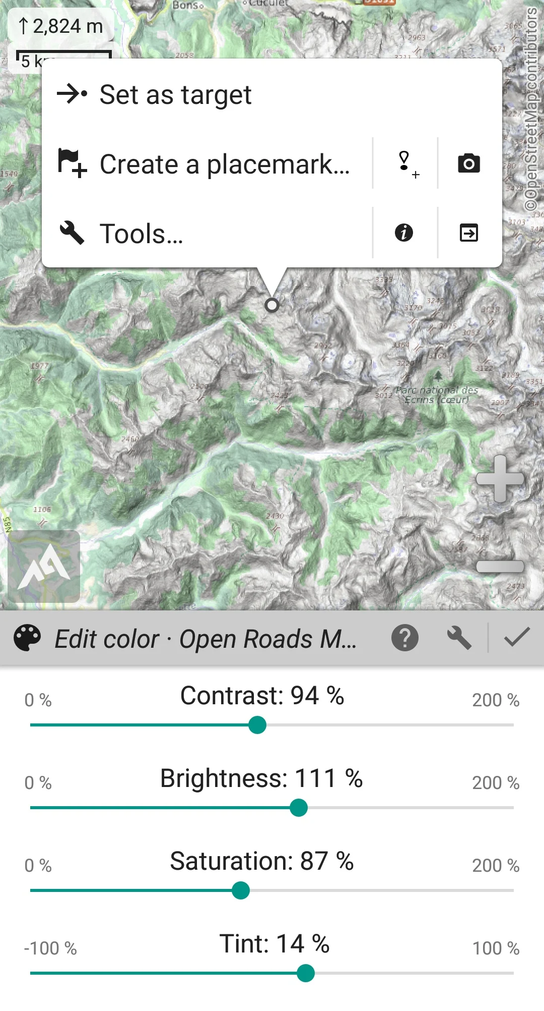
• Layered display of multiple maps, with control over opacity, contrast, color, tint, and blending per map.
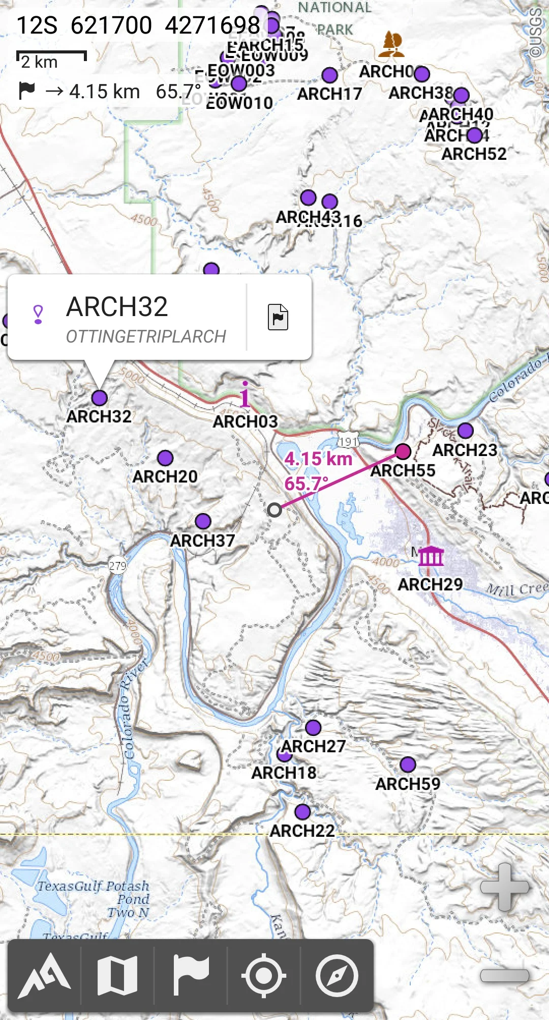
★★ Placemarks ★★
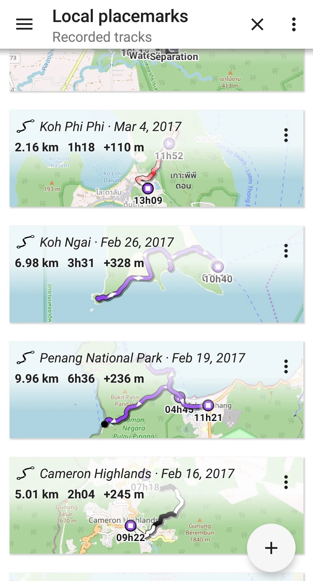
• Create, display, save, restore an unlimited number of items (waypoints, routes, areas, tracks);
• Import/export GPX, Google Earth KML/KMZ, CSV/TSV files, ShapeFile SHP/PRJ/DBF, OziExplorer WPT/PLT, GeoJSON, IGC tracks, Geocaching LOC waypoints, AutoCAD DXF files;
• Share locations online with other users using Community Placemarks;
• Detailed information, advanced statistics, interactive graphics on various items;
• Time Controller for replaying time-tagged tracks.
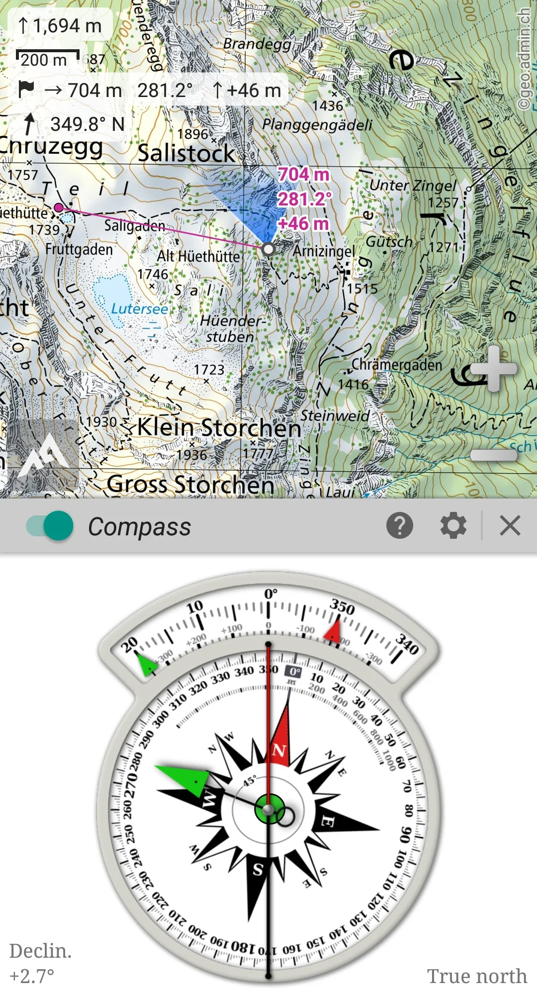
★★ GNSS Position / Orientation ★★
• On-map geolocation using device GNSS receivers (GPS/Glonass/Galileo) or Network;
• Map orientation, compass, target finder;
• Built-in GNSS/Barometric track recorder with long tracking capabilities, separate light process, battery level, network strength recording;
• Proximity alerts, leave path alerts;
• Barometer support on compatible devices.
★★ And More ★★
• Metric, imperial, nautical, hybrid distance units;
• Latitude/Longitude, grid coordinate formats (WGS, UTM, MGRS, USNG, OSGB, SK42, Lambert, QTH), on-map grids display;
• Import hundreds of coordinate formats from spatialreference.org;
- Version2.3.9d
- UpdateApr 07, 2025
- DeveloperPsyberia
- CategoryTravel & Local
- Requires AndroidAndroid 2.1+
- Downloads2M+
- Package Namepsyberia.alpinequest.free
- Signatureb7cdb4f2e0add438867145b3de707504
- Available on
- ReportFlag as inappropriate
-
NameSizeDownload
-
8.34 MB
-
8.33 MB
-
8.21 MB


Provides multiple map sources
Supports creating and tracking routes
Supports importing and exporting GPS data
In some environments, GPS positioning may not be accurate enough, affecting navigation results
Downloading map data may take up a lot of storage space