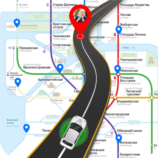
GPS Route Finder - Find quickest routes
Discover quickest routes, find locations effortlessly with GPS Route Finder
- 2.0.72 Version
- 2.9 Score
- 18M+ Downloads
- Free License
- 3+ Content Rating

Introducing GPS Route Finder
Maps Navigation & Directions offers numerous features including GPS shortest Route finder, Driving route, Current Location, Maps Navigation, GPS Area Calculator, Maps Tracker, Weather Updates, Traffic Updates, GPS Speedometer, Distance Calculator, International subscriber dialing (ISD) or Country Codes, City Codes (STD) codes (USA, India, Pakistan), Altitude meter, and more - making everything simple and convenient!
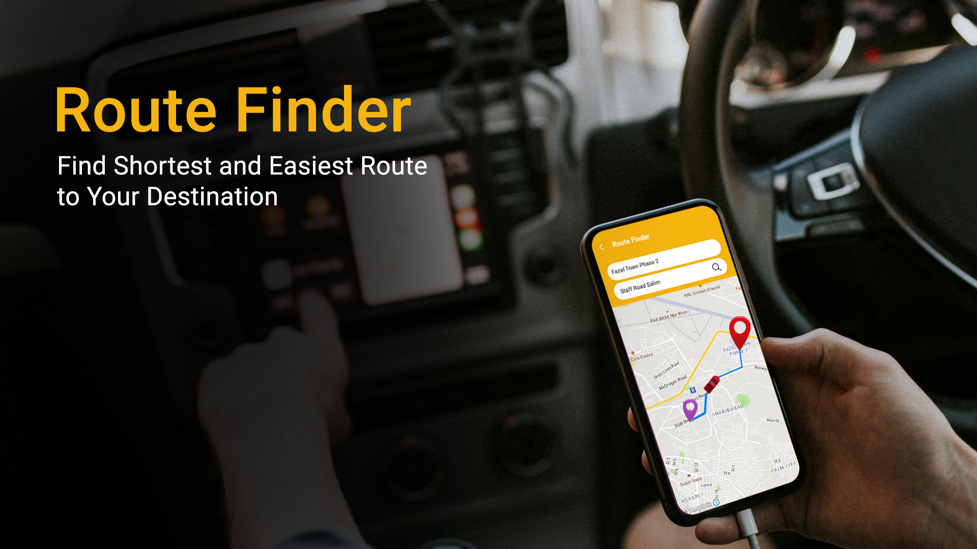
Maps Navigation - Route Planner utilizes GPS & Network to pinpoint your location on Maps, enabling easy navigation and providing necessary directions. Route Finder facilitates Map navigation and aids in reaching your destination. Although offline maps navigation is not supported, your device needs to be connected to 3G, 4G, or WIFI to use this feature effectively.
Important: Ensure that GPS & network are connected before using this GPS Route Finder app.
GPS Route Finder: Maps Navigation & Directions Features include:
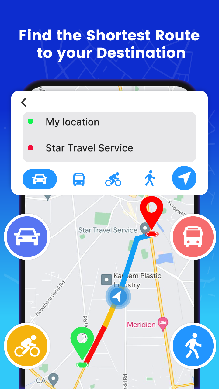
• GPS Route Finder: Helps users find the shortest and easiest path to their destination, along with distance and estimated travel time. This feature also provides voice GPS Driving Directions and Navigation services on Maps.
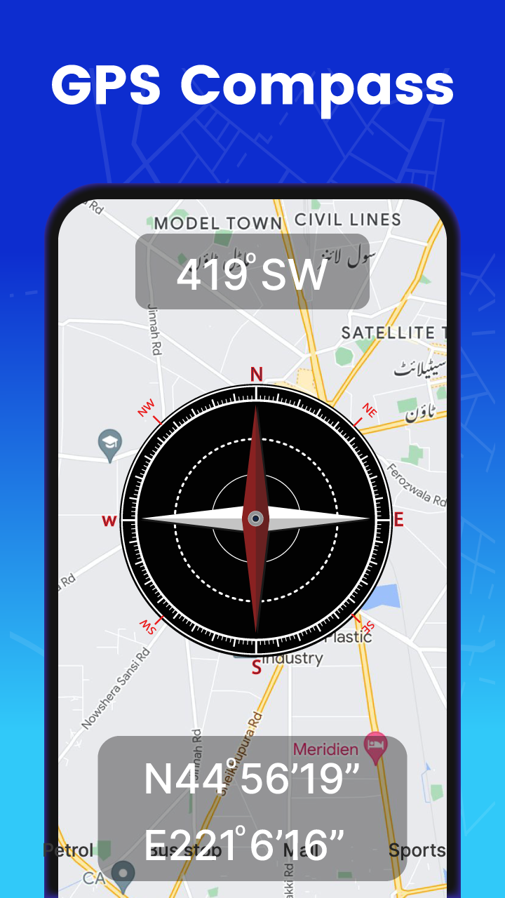
• GPS Speedometer: Measures the speed of various modes of transportation and displays the speed limit in both analog and digital formats. This handy app can track time, speed, and distance traveled.
• Maps Tracker: An excellent tool for outdoor enthusiasts and travelers, this feature uses GPS to track the current location and address of a phone or device for mobile phone location tracking.
• Weather Updates: Offers important weather forecasts such as pressure, visibility, humidity, and speed to help users prepare their plans accordingly and enhance their daily lives.
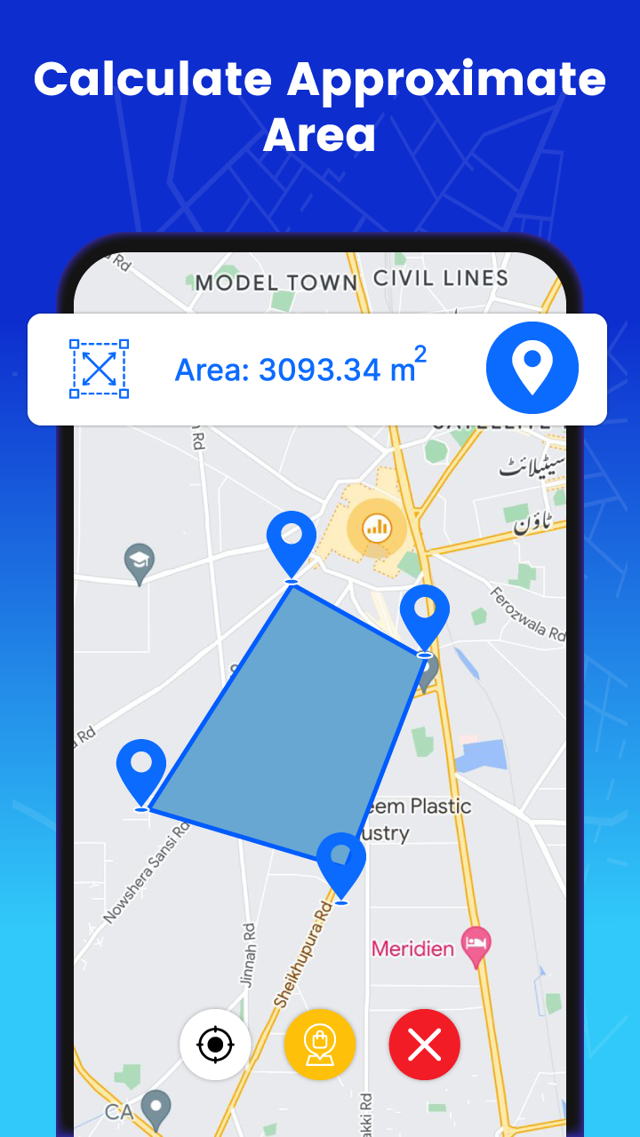
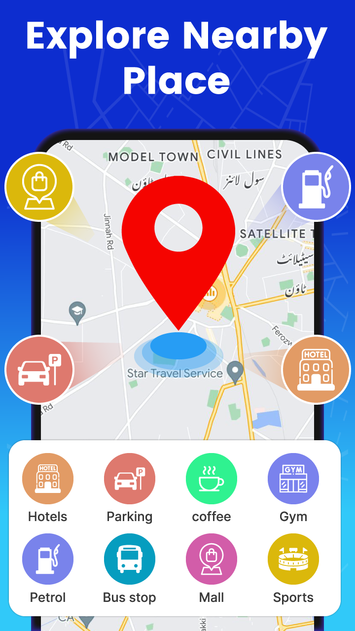
• Area Calculator On Map: A precise tool for measuring areas on the map, allowing users to calculate the total area of land by placing points and determining the area between them. Different map views like Normal, Satellite, Terrain maps, and Search map are available.
• Distance Calculator On Map: Calculates the distance between two points on a map and allows users to determine distances between different locations with ease.
• Country Codes ISD: Provides all country codes within the app for free, aiding users in identifying the origins of foreign messages or researching different countries without an internet connection.
• Qibla Direction: Enables Muslim users worldwide to locate the exact direction of Qibla towards the Holy Kaaba using a unique and user-friendly Qibla Compass feature.
• My Current Location/Mobile Location: Helps users identify their current position if they are lost or have forgotten their address. Please note: The app does not track users in the background or use background location services.
What is GPS Route Planning?
GPS (Global Positioning System) route planning is simply planning delivery routes using identified addresses and navigating between them with the use of GPS navigation. Let’s explore some of the key aspects of the technology and how these capabilities can help logistics companies plan routes.
Key Aspects of GPS Route Optimization
Location Tracking: With 24 satellites in orbit, the GPS network can pinpoint the exact location of any vehicle with a GPS signal receiver. This can help drivers and dispatchers manage the location of goods and derive ETA information for deliveries.
Mapping and Navigation Services: GPS platforms typically provide mapping services to overlay the location of a receiver on top of known locations. These platforms can further provide navigation and routing information based on roads, airways or shipping lanes.
Route Calculation: GPS algorithms can use the map and location data to create optimized routes for delivery vehicles, using variables such as distances, speed limits, tolls, traffic and more.
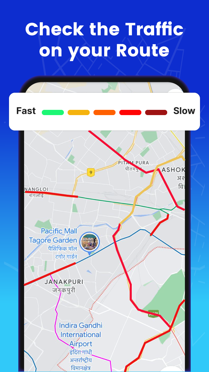
Real-Time Traffic Updates: Due to the network effect of many GPS users, GPS platforms can calculate real-time traffic updates by monitoring where users are going more slowly on a road than typical traffic flows move. This identification of traffic hot spots can be used to inform drivers of delays and even reroute them around delays.
Turn-by-Turn Directions: Drivers using GPS navigation platforms can receive turn-by-turn navigation information as they drive a delivery route. This is critical in adhering to pre-planned routes and can be updated as traffic, weather, or other factors change.
How does GPS Route Planning Work?
The key capabilities of GPS routing are critical for last-mile logistics efficiency. But how do they actually work?
GPS Data Acquisition: GPS route planning begins by acquiring mapping and positioning data. Onboard equipment receives GPS signals to determine the precise location of a vehicle.
Mapping Data Retrieval: Once the location is received and determined, a GPS unit must retrieve built-in mapping data to overlay location coordinates onto. Destination coordinates can be input and routing can begin. The mapping data includes roadways that link the beginning points, end point and stopping points along a route.
Route Calculation: The GPS route planning algorithm can then process the intended stopping points and links the most efficient roadways and routes of travel between them, accounting for traffic, weather, tolls and other factors.
Traffic Information Integration: Real-time traffic information can be calculated in most modern GPS systems. This is done by determining any slow moving or stopped points along a roadway from data of other GPS users.
Route Optimization: The real magic occurs when routes are optimized for various constraints, such as toll roads, traffic, parking spots, regulated roadways and others. Modern logistics GPS platforms can account for these to create optimal routes that contain hundreds of stops.
What is Route Management? The Ultimate Guide to Manage Routes Effectively
GPS Technology and Components
A. Overview of Global Positioning System (GPS):
The Global Positioning System (GPS) is a network of 24 satellites that locate and provide information to GPS receivers. There are many components of this system. We’ll explore a quick overview of these components below.
B. GPS Components: Satellites, Receivers, and Navigation Devices:
Satellites: The GPS system includes a constellation of satellites orbiting the Earth. Currently, there are approximately 30 operational GPS satellites distributed across six orbital planes. These satellites continuously transmit signals that include precise timing information and satellite position data.
Receivers: GPS receivers are devices that receive signals from multiple GPS satellites. They typically contain an antenna to capture the satellite signals, a processor to perform calculations, and memory to store data. The receiver processes the signals and extracts information about the satellite positions and time.
Navigation Devices: Navigation devices, such as dedicated GPS units or GPS-enabled smartphones, incorporate GPS receivers and additional software to provide navigation capabilities. They receive signals from multiple satellites and use the information to calculate the device's position, speed, and heading.
C. Role of GPS in Route Optimization and Navigation Systems:
GPS plays a fundamental role in route planning as the information provided can help find optimal routes between intended locations on the earth’s surface. Here are the key elements of GPS and how they help logistics managers plan efficient routes.
Location Determination: GPS signals can pinpoint within a few meters the exact location of a receiver on the earth’s surface. This can help drivers navigate complicated routes with extreme accuracy.
Mapping and Digital Maps: Most GPS navigation devices include databases of up-to-date maps for regions around the globe. Combining location data with these maps can create complete awareness of a vehicle’s location on the Earth’s surface.
Route Calculation: With the comprehensive mapping data, routes can be calculated between multiple points using the roadways most efficient for each route. Routes can account for various constraints along the way.
Turn-by-Turn Directions: Drivers using GPS devices can receive turn-by-turn instructions to assist them in navigating complicated road networks and ensure they stay on course throughout a delivery route.
Real-Time Traffic Updates: Most GPS navigation systems incorporate real-time traffic information by accessing traffic data, such as congestion, accidents, or road closures. These traffic updates can be used to inform drivers of more efficient routes where possible.
Tracking and Monitoring: GPS technology enables tracking and monitoring of vehicles in real-time for both drivers and other stakeholders, such as dispatchers, managers and even customers waiting for deliveries. Managers can use this information to monitor performance and provide even more efficient routes in the future.
Benefits of Route Planning
GPS route planning offers several benefits for individuals and businesses alike. Here are some of the key advantages:
Accurate Navigation: GPS systems provide the most accurate navigation possible for road-based vehicles today, calculating positions within meters of the actual position on the Earth’s surface. These positions can be compared against mapping data to provide extremely accurate navigation along a route.
Time and Fuel Efficiency: Because GPS systems can calculate the shortest distance to travel between multiple stops, GPS route planning ensures delivery vehicles can complete delivery routes in the least amount of time possible while using as little fuel as possible, saving both time and money for logistics providers.
Improved Productivity: Drivers using GPS systems are able to complete more stops per hour and more stops per route hour versus similar drivers using more manual navigation methods. This translates to increased driver productivity and can reduce the amount of vehicles or drivers a logistics provider may need for a given number of deliveries.
Enhanced Safety: GPS routes can help drivers avoid potentially hazardous areas, such as areas of high traffic congestion, bad weather and poor road conditions. Further, drivers can focus on driving their vehicles with automated turn-by-turn navigation to help keep their eyes on the road.
Simplified Trip Planning: Most importantly, drivers and dispatchers can save hours planning routes with modern GPS route planning software. By inputting desired stopping locations, dispatchers can create efficient, optimized routes within seconds using GPS data and coordinates.
- Version2.0.72
- UpdateSep 12, 2024
- DeveloperLuko Parallel App Pvt Ltd
- CategoryMaps & Navigation
- Requires AndroidAndroid 5.0+
- Downloads18M+
- Package Namecom.prime.studio.apps.route.finder.map
- Signature1fdaa86eed7a002101138e8a884a4b2f
- Available on
- ReportFlag as inappropriate
-
NameSizeDownload
-
21.23 MB
-
8.52 MB
-
4.06 MB


safely navigated home without network
almost always accurate
no directing arrow in front